How the Bosphorus shaped empires is a story of a narrow, shimmering strait that became a decisive threshold for power, trade, faith, and knowledge—its waters choreographing the rise of cities, the reach of armies, and the transformations of human consciousness across continents and eras.
- The Bosphorus is a geographic threshold where continents, seas, and cultures intersect dynamically.
- Control of the strait has repeatedly redirected trade, war, religion, and imperial ambition.
- As a liminal space, it reveals how landscapes sculpt knowledge, identity, and spiritual imagination.
The Strait As A Threshold Of History And Noesis
To stand before the Bosphorus is to encounter a living line: neither fully land nor fully sea, neither entirely Europe nor entirely Asia. It is a threshold, and thresholds are where noesis—insightful perception—tends to sharpen.
From an interdisciplinary perspective, the Bosphorus is not merely a waterway. It is a geographic hinge that has invited empires, a spiritual symbol of crossing, and an epistemological doorway into how humans organize power, trade, and meaning. Greek city-states, Byzantine emperors, Ottoman sultans, and modern Turkish leaders have all understood that whoever commands this strait also shapes a vast surrounding cosmos of relations.
In this sense, to ask how the Bosphorus shaped empires is also to ask how landscapes influence forms of knowledge: how topography writes itself into law codes, liturgies, ship routes, and collective memory.
Geography Of The Bosphorus: A Natural Corridor Between Worlds
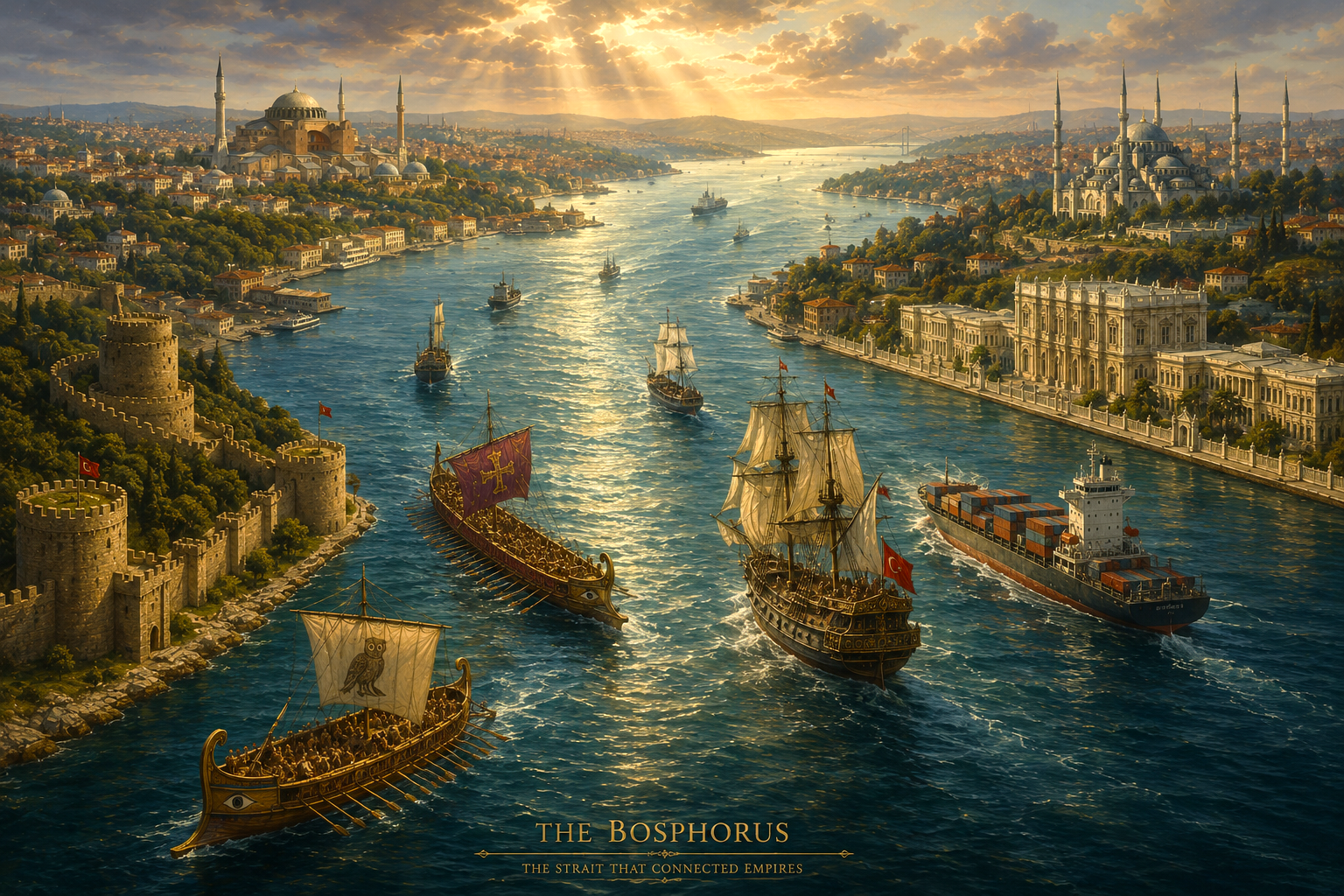
The Bosphorus is a relatively short strait—about 30 kilometers in length—yet its significance is out of all proportion to its size. It joins the Black Sea in the north to the Sea of Marmara in the south, and through the Dardanelles ultimately to the Aegean and Mediterranean.
The strait narrows to barely 700 meters at some points. Steep hills rise on both sides, shaping wind and current patterns. Below the surface, complex layered currents flow: cooler, less saline Black Sea waters move southward near the top, while heavier Mediterranean waters push northward below. This double current once challenged sailors; today it continues to influence navigation and ecology.
Geographically, the Bosphorus also forms a vivid segment of the boundary between Europe and Asia. The line is conceptual—tectonic plates and cultural histories are more entangled than any neat border—but the visual impression is powerful: mosques and modern towers, palaces and wooden yalıs, mirrored in a watercourse that is itself always in movement.
As a natural corridor, the strait became a rare point where geography compresses vast distances. Grain from the Eurasian steppe, furs from the north, textiles and ideas from the south, and later oil and manufactured goods—all have passed through this narrow passage. The Bosphorus therefore functions as a geographic amplifier: small in dimension, immense in consequence.
Empires On The Waterway: From Ancient Greeks And Byzantium To The Ottomans And Modern Türkiye
Long before global maps were drawn, ancient Greeks recognized the Bosphorus as a vital crossing. According to myth, Io—transformed into a cow—swam these waters, giving the strait its name: the “ox-passage.” Around this mythic spine, early Greek colonies such as Byzantium and Chalcedon arose, positioning themselves to tax and protect trade flowing between the Black Sea and the wider Mediterranean.
When the Roman Empire fractured, the city of Byzantium—refounded by Constantine in the 4th century as Constantinople—became the imperial answer to the strait’s possibilities. Its walls overlooked the meeting of waters; its harbors sheltered fleets; its churches and forums staged a Christian-Imperial vision bridging provinces from the Balkans to the Near East. Here geography crystallized into a new center of the world for those within its orbit.
The Ottoman capture of Constantinople in 1453 did not diminish the Bosphorus; it reinterpreted it. Under the Ottomans, the renamed İstanbul became a capital where Islamic jurisprudence, Sufi orders, and imperial bureaucracy coexisted around the same waterway. Control of both banks of the Bosphorus, and later the Dardanelles, allowed the empire to moderate access between the Mediterranean and the Black Sea, tying regional powers into an Ottoman-centered trade and security system.
In the 20th century, as the Ottoman Empire dissolved and the Republic of Turkey emerged, the Bosphorus again became a focal point. The 1936 Montreux Convention formalized Turkish control over the straits while guaranteeing the passage of civilian vessels. The modern Turkish state inherited not only the physical waters but centuries of accumulated symbolism: a responsibility and an opportunity to reinterpret the strait within an international order transformed by industrialization, nationalism, and new technologies. (The Turkish Straits)
Across these epochs, empires did not simply occupy the Bosphorus; they were in turn defined by their relationship to it—militarily, economically, and spiritually.
Trade, War, And Power: Geopolitics Of A Narrow Passage
Because the Bosphorus is a bottleneck, it has repeatedly become a focal point for both negotiation and conflict. Whoever commands this passage influences who may sail from the Black Sea to the world’s oceans and who remains enclosed.
For Black Sea polities—from medieval principalities to modern states such as Russia and Ukraine—the route through the Bosphorus has been essential for exporting grain, oil, and other goods. For external powers, from Venice and Genoa to later European empires, the strait represented a gate through which commerce and influence could be extended into the Eurasian hinterlands.
The strategic logic is simple: a narrow passage is easier to control than wide seas. Yet its geopolitical implications are intricate, touching diplomacy, war, and maritime law. The Ottomans fortified both shores with castles and gun emplacements. In later centuries, treaties sought to regulate access, reflecting an evolving recognition that the Bosphorus was not merely a local concern but a matter of global maritime equilibrium.
Table: How Geography Translates Into Power
| Dimension | Geographic Feature Of The Bosphorus | Resulting Form Of Power Or Influence |
|---|---|---|
| Trade Routes | Single outlet from the Black Sea to Mediterranean | Ability to tax, regulate, or block regional commerce |
| Military Control | Narrow width and high banks | Easier defense, strategic chokepoint in times of conflict |
| Political Status | Border between continents and regions | Symbolic capital for imperial and national legitimacy |
| Cultural Flow | Crossroads of routes from Europe and Asia | Dense exchange of languages, religions, and practices |
Through this lens, the Bosphorus becomes an example of how physical geography writes itself into political life: maps become policies, currents become treaties, and shorelines become frontiers in both material and symbolic senses.
Aesthetic And Cultural Imaginaries: The Bosphorus In Art, Architecture, And Literature
Beyond armies and trade, the Bosphorus has long inhabited the realm of aesthetics. Painters, poets, architects, and mystics have perceived in its changing light a metaphor for connection and separation.
Ottoman miniatures, European travel paintings, and later photographic works document the strait as a scene of layered beauty: wooden mansions leaning over the water, domes and minarets punctuating the skyline, fishermen and ferries tracing quiet arcs. Each image is more than representation; it is an interpretation of how humans dwell at a hinge of worlds.
Architecturally, the Bosphorus is framed by palaces such as Dolmabahçe and Beylerbeyi, by fortresses like Rumeli Hisarı and Anadolu Hisarı, and by a mosaic of mosques, churches, and synagogues dispersed along its shores. These structures testify to the coexistence—sometimes tense, sometimes harmonious—of diverse communities: Greek Orthodox, Armenian, Jewish, Muslim, and others. The skyline is thus an archive of plural identities inscribed in stone and timber.
In literature, the strait often appears as a site of reflection. Writers from different traditions have used it as a setting where characters confront memory, longing, and the question of belonging: Are they of one shore or the other, or of the water between? This recurring motif reveals an aesthetic intuition that the Bosphorus is not only a location but a state of mind.
Through the noetic lens, such aesthetic expressions are not ornamental. They are modes of knowledge—ways of understanding a landscape and our place within it that no map or treaty can fully contain.
Philosophical Reflections: Liminality, Empire, And The Noetic Bridge Between East And West
To regard the Bosphorus philosophically is to contemplate liminality: the quality of being at the threshold. Anthropologists describe liminal spaces as those in which customary categories loosen, allowing transformation. The Bosphorus is a geographic embodiment of this principle.
Here, the familiar binary of “East” and “West” reveals its limits. On the ground—and on the water—identities and influences blur. Byzantine rituals absorbed elements from older Mediterranean practices; Ottoman administration synthesized legal and cultural forms from Arab, Persian, and Turkic traditions, while governing Orthodox and Jewish communities within the same city. Modern İstanbul continues this interplay, with neighborhoods and individuals carrying layered affiliations that resist simple classification.
In epistemological terms, the Bosphorus invites us to reconsider how we know the world. We often think in bounded units: nation-states, civilizations, discrete religious or philosophical systems. Yet the strait shows that much of history unfolds not at the center of such units, but at their edges—where they meet, negotiate, borrow, and reconfigure.
Noesis, as a refined act of insight, means attending to these edges rather than only to the centers. By studying a single strait, we discover patterns of connection that might otherwise remain invisible: how trade routes become vectors of ideas, how cities at crossroads generate hybrid philosophies, how thresholds can be spaces of both vulnerability and creativity.
In this sense, the Bosphorus becomes a noetic bridge: not simply between East and West as abstract blocks, but between different modes of being and knowing—between maritime and continental perspectives, imperial and local memories, material needs and spiritual search.
What A Strait Teaches Us About Connection, Empire, And Conscious Curiosity
Returning to the guiding question—how the Bosphorus shaped empires—we can see that the answer extends beyond any single dynasty or treaty.
Geographically, the strait concentrated routes and resources, enabling cities and empires to flourish by mediating between seas and continents. Politically, it offered leverage: control the Bosphorus, and you influence entire regions. Culturally and spiritually, it cultivated an enduring experience of in-betweenness that fostered rich, if sometimes fragile, forms of coexistence.
The deeper lesson lies in conscious curiosity. The Bosphorus shows that to understand power and identity, we must attend not only to grand abstractions—”East,” “West,” “empire”—but to the precise landscapes where these forces materialize and intermingle. An interdisciplinary gaze that unites geography, history, philosophy, and aesthetics reveals the strait as a teacher of connection: its waters reminding us that boundaries can divide, but they can also relate.
In contemplating this narrow passage, we practice a broader art of noesis: discerning how the seemingly local is woven into the vast human and planetary cosmos. The Bosphorus becomes more than a chapter in regional history. It stands as a metaphor for every threshold we cross—in politics, in culture, and within our own inner landscapes—where the unknown invites us to step forward with both intellect and intuition.
Frequently Asked Questions
How did control of the Bosphorus influence trade between the Black Sea and the Mediterranean?
Control of the Bosphorus allowed empires to tax, regulate, or block ships moving between the Black Sea and the Mediterranean. Ancient Greek poleis, the Byzantine Empire, and the Ottomans all leveraged the strait to redirect strategic commodities like grain and silk, fundamentally shaping regional wealth and imperial longevity.
What role did the Bosphorus play in imperial military strategy and naval warfare?
The Bosphorus forced empires to design specialized fortifications, naval fleets, and campaigns around its narrow maritime chokepoint. Defensive Byzantine chains, massive Ottoman shore fortresses, and continuous naval patrols turned the strait into both a shield and a sword, enabling rapid troop movement and blockades that decided major wars.
How did Bosphorus geography dictate urban planning in Constantinople and Istanbul?
The steep hills and dual shorelines of the Bosphorus dictated the placement of harbors, palaces, and defensive walls. Byzantines concentrated their imperial and ecclesiastical complexes near natural anchorages on the Golden Horn, while the Ottomans extended the city along the Bosphorus waterfront, aligning mosques and markets with key maritime routes.
How did the Bosphorus influence spiritual metaphors and religious thought?
The Bosphorus functioned as a visible threshold between continents, inspiring myths of crossing, sacred pilgrimage routes, and theological metaphors of passage. Greek, Christian, and Islamic traditions utilized the strait’s inherent liminality to frame complex ideas of exile, revelation, and divine guidance, effectively embedding geography into religious thought.
Why is the Bosphorus a recurring theme in imperial art and architecture?
The Bosphorus combines strategic geopolitical gravity with striking natural beauty, making it a persistent subject for imperial poets, painters, and architects. Panoramic shorelines and shifting light allowed empires to project power aesthetically through waterfront palaces, while artists utilized the strait to explore universal themes of horizon, boundary, and encounter.
Further Reading & Authoritative Sources
Authoritative Sources
- Crocevia di Imperi: la lunga Storia di Bosforo e Dardanelli — University of Genoa academic thesis (Italian, .edu-linked repository) analyzing how the position of the Bosphorus and Dardanelles has been decisive for centuries in shaping the dynamics and power of surrounding states and empires, with a focus on their geopolitical and economic impact.