A reflective, practical guide to crossing Siberia’s frozen highways — focusing on the Kolyma Highway (Road of Bones), winter logistics, permafrost science, and ethical travel.
Overview & The Kolyma Highway
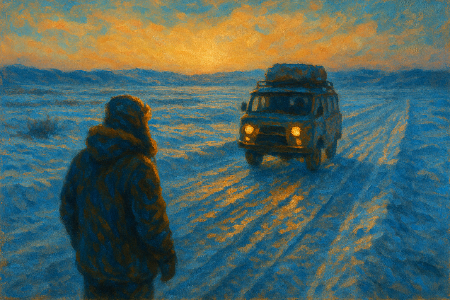
When people speak of the loneliest road in the world they are often referring to stretches of the R504, the Kolyma Highway — the infamous Road of Bones linking Yakutsk to Magadan. Yet, in winter, “crossing Siberia’s frozen highways” means more than the R504 alone: zimniks (seasonal winter roads), frozen river bridges, and ice tracks create a fragile network that briefly opens remote landscapes to vehicles and cargo.
Briefly: the Kolyma Highway runs ~2,000–2,100 km across boreal forest, tundra, and permafrost. The route is logistically demanding, historically charged, and ecologically vulnerable; therefore, planning, local knowledge, and humility are essential.
To put scale in perspective: a single stretch between fuel stops can be 200–400 km, and temperatures commonly range from -30 °C to below -50 °C in deep winter. These are not just long days of driving — they are a sustained test of equipment, decision-making, and psychological endurance. When crossing Siberia’s frozen highways you are simultaneously traveling through living geology: frost heave, thermokarst lakes, and seasonal ice bridges all govern where and when a vehicle can safely pass.
When & Why to Go (Best Time and Intent)
- Best window: December–March, with January–February offering the most stable ice roads and zimniks.
- Avoid: shoulder months (November, April) because freeze–thaw cycles produce slush, weak river ice, and rapid road deterioration.
Why go? For many travelers it is both a challenging winter road trip and an encounter with scale and silence; for supply chains it remains a crucial seasonal corridor. Researchers and environmental monitors also use these windows to install sensors and access remote permafrost sites. For indigenous communities the seasonal roads can be essential lifelines for supplies, but they are also disruptive when traffic and waste are not managed respectfully.
Logistics for Crossing Siberia’s Frozen Highways — Vehicle, Safety, and Packing
Vehicle preparation for extreme cold (Vehicle prep & winter tires)
Your vehicle is your lifeline. For driving in Siberia, choose a heavy-duty 4×4 (e.g., Toyota Land Cruiser, UAZ utility rigs) or hire a reputable Siberia 4×4 rental in Yakutsk. Must-haves:
- Engine block heater, battery warmer, and insulated fuel lines.
- High-quality studded or Arctic winter tires; carry at least two spares.
- Recovery gear: winch, tow straps, shovel, traction boards.
- Extra fuel: fuel stops on the Kolyma Highway can be hundreds of kilometers apart.
- Reinforced radiator mesh and high-altitude air filters for dusty spring sections; consider dual-battery setups and an auxiliary heater for long nights.
Routine vehicle checks every morning are critical: inspect tire pressures (cold air reduces pressure), battery voltage, coolant and oil levels, and verify that heaters and defrosters are working. A small checklist taped inside the cabin saves time and prevents oversight.
Safety tips for Siberian ice roads (communication & emergency kit)
- Communication: satellite phone or a satellite messenger (e.g., Garmin InReach). Cellular coverage is spotty to non-existent.
- Never travel alone: travel in convoy or hire a local guide; local truckers are an essential source of up-to-date road intelligence.
- Emergency kit: arctic-rated sleeping bags, high-calorie food, water-melt tools, first-aid, fire-starting kit, repair tools, spare belts and fluids.
Case study: a convoy of five vehicles in February 2019 encountered a washout near a tributary of the Kolyma. The lead truck fell through newly formed slush; thanks to chiselled ice observation and a winch-equipped rescue vehicle the group recovered the truck and evacuated the driver. The incident underlines the value of convoy protocols — keep distance, maintain visual contact, and assign roles (lead, sweep, comms) before departure.
What to pack for a Siberian road trip (what to pack & clothing)
Pack for extreme cold: thermal base layers (merino), fleece mid-layers, heavy down parka, insulated trousers, balaclava, mittens, and boots rated to -40 °C. For photography and electronics: keep batteries warm inside clothing and carry spares.
Practical packing tips:
- Store medical supplies and high-calorie food in heat-insulated containers to prevent freezing.
- Keep a small stove and fuel to melt snow for water — boiling preserves. A lightweight foldable shovel speeds extraction from snowdrifts.
- Mark equipment and fuel containers clearly (both in Latin and Cyrillic if possible) to ease transfers with locals.
Route & Itinerary — Magadan to Yakutsk (Magadan to Yakutsk road trip itinerary)
The route can be driven either direction. Key sections often cited by drivers and guides:
- Yakutsk → Ust-Nera: the edge of the cold; expect deep cold, narrowing roadways and sparse services.
- Ust-Nera → Khandyga: the boreal expanse; long distances between fuel and food, watch for ice bridges and roadside relics.
- Khandyga → Magadan (Kolyma stretch): the classic Road of Bones — volcanic ridges, tundra, and the stark emptiness that made the route legendary.
Plan conservatively: 5–10 days of driving depending on conditions and stops.
Step-by-step sample itinerary (10 days):
- Day 1 — Yakutsk: final checks, obtain permits, hire local guide.
- Days 2–3 — Yakutsk to Ust-Nera: break into smaller driving legs, test comms and heating systems.
- Day 4 — Resupply and local museum visit: contextualize the Road of Bones history.
- Days 5–7 — Mid-route push: longer legs, plan daylight-only crossings of river ice bridges.
- Day 8 — Buffer day for weather or vehicle repair.
- Days 9–10 — Kolyma approach and arrival in Magadan: formalities and rest.
Allow an additional two days for contingency; weather and ice conditions can close segments with little notice.
History and Ethics: Road of Bones, Gulag Memory, and Respectful Travel (Road of Bones)
The nickname “Road of Bones” evokes a painful history: during the 1930s–1950s many road and infrastructure projects in northeastern Siberia were constructed by forced labor from Gulag camps. Literary and historical sources like Varlam Shalamov’s testimony and scholarly histories (e.g., Anne Applebaum) document the brutality and high mortality associated with those projects. Travelers must approach memorial sites and local memories with respect: do not sensationalize suffering.
Expanded context: many small memorial sites are informal — stone cairns, rusted markers, or even unmarked places along the roadside. Local historians and surviving family networks often maintain memory in ways that are not obvious to outsiders. If you plan to photograph or publish images of memorials, ask permission where possible, and include accurate captions that reference the historical context rather than using the imagery purely for dramatic effect.
Ethical checklist for sites:
- Pause and learn: spend time at a site rather than drive-by photography.
- Donate to local museums or memorial funds if you benefit from their knowledge or guides.
- Report artifacts: removing relics from sites can be illegal and disrespectful.
Climate & Landscape Science: Permafrost, Ice Roads, and Change (permafrost roads)
Permafrost underlies much of northeastern Siberia and provides the frozen foundation on which routes and zimniks rely. Thawing permafrost destabilizes roads, raises maintenance costs, and releases greenhouse gases stored in soils. Consequently, crossing Siberia’s frozen highways is increasingly influenced by climate variability and warming winters — a central logistical and ethical consideration for planners and travelers alike.
Expert insight: a permafrost researcher notes, “The margin for error shrinks every decade. Surface indicators like small thermokarst ponds or new slumps often precede major failures of ice-road sections.” This combination of subtle early-warning signs and rapidly changing conditions means that continuous local reconnaissance matters more than static maps.
Comparative analysis: zimnik versus engineered winter roads
- Zimniks (audible, seasonal): cost-effective, follow the terrain and river ice, but are temporary and highly vulnerable to warm spells.
- Engineered winter roads: reinforced with gravel and drainage, used in some industrial corridors, more expensive but more resilient.
Transportation planners increasingly weigh the long-term emissions and social costs of building permanent roads through permafrost versus relying on seasonal ice corridors.
Guided Tours, Operators, and When to Hire Help (Kolyma highway tour packages)
Most non-expert travelers should prefer guided Siberia ice road tours or book services with experienced local operators. Benefits:
- Professionally prepared vehicles and drivers familiar with zimniks and fuel logistics.
- Pre-arranged accommodation, permits, and contingency plans.
- Lower personal risk and a better chance to learn from local communities.
How to choose an operator:
- Ask about maintenance logs for vehicles and the number of winters the guide has worked on the route.
- Request a sample emergency plan and insurance details.
- Prefer operators who show evidence of community engagement — hiring local drivers, sourcing supplies locally, and explaining memorial etiquette.
Cost snapshot: guided trips range widely depending on vehicle standard, group size, and inclusions. Budget operators might offer shared 4×4 rides and basic accommodation, while high-end operators provide bespoke vehicles, translators, and photographic support. Expect higher costs due to fuel, logistics, and the need for contingency equipment.
Photography & Aesthetics: Tips for the Road of Bones (photography spots)
- Use negative space to show scale. Include a human subject or rusted sign for context.
- Side-lighting reveals snow texture; long exposures can render passing headlights as light ribbons.
- Keep captions factual: location, recorded temperature, and a short contextual note (e.g., memorial site).
Equipment checklist for photographers:
- Cold-rated batteries and insulated pockets; lithium batteries perform better in cold.
- Tripod with spiked feet for stability on ice.
- Wide-angle lens for landscapes and a mid-range telephoto for compressing distant ridges.
- Lens cloths and silica gel packs to reduce condensation.
Ethical reminders for photographers: avoid using imagery of skeletal remains or exposed graves as sensational content. If photographing people, obtain informed consent and consider compensating guides and local hosts for their time.
Practical Takeaways: Quick Checklist for Crossing Siberia’s Frozen Highways
- Best months: December–March; January–February most stable.
- Vehicle: winterized 4×4, studded tires, extra fuel.
- Safety: satellite comms, emergency kit, travel with locals or in convoy.
- Respect: treat Gulag-era sites and indigenous communities with humility and care.
Actionable daily routine when on the road:
- Morning: check weather bulletins, tire pressure, battery voltage, and fuel levels.
- Midday: confirm next fuel stop and assess daylight remaining for planned crossing points.
- Evening: brief the convoy, check sleeping systems, and perform minor repairs while warm.
Further reading & authoritative sources
- Schuur, E. A. G., et al., “Vulnerability of Permafrost Carbon to Climate Change” (Nature Geoscience, 2015).
- IPCC Sixth Assessment Report — relevant sections on permafrost and Arctic change.
Join the Conversation
Have you crossed an extreme landscape that changed your thinking? Share a short reflection or image via our newsletter and join thenoetik’s community of readers who pair curiosity with reverence.